
Image generated with Ai
The intensification of climate fluctuations in oceans is pushing marine tourism to shift from being reactive about environmental destruction to being proactive about destination management. Using predictive hydrodynamic early warning systems, tourism operators can no longer simply respond to environmental degradation. Rather, it is seasonal forecast models that are revolutionizing predictive conservation travel by enabling chartered trips, researchers, and resort managers to prepare tourists in advance of the ecological calamities. With the preparation and recruitment of divers well in advance of predicted temperature changes, the travel website turns snorkeling tourists into trained environmental responders. This predictive model not only protects the sensitive marine areas but also creates opportunities for profitable scientific exploration tours.
For generations, the global marine tourism sector has operated within an emergency response paradigm. Following acute marine warming events or widespread coral bleaching episodes, coastal tourism operators, conservation bodies, and marine park authorities historically mobilized post-disaster assessments to document ecological decline. This retrospective operational model proved fundamentally reactive: charter vessels conveyed visitors to unblemished outer reefs until thermal anomalies triggered mass mortality, leaving tourism destinations to manage localized revenue deficits, brand erosion, and negative international headlines.
Advertisement
In multiple vulnerable marine ecosystems, this operational lag gave rise to “last chance tourism,” a commercial pattern where travel providers marketed the impending degradation of fragile habitats to capture short-term booking demand. While generating transitory revenue spikes, this approach compounded environmental pressure on compromised ecosystems without producing tangible conservation mechanisms or financial pathways for ecological recovery.
The systemic weaknesses of this reactive framework became unmistakably clear during the 2024–25 Southern Hemisphere summer, which registered as the warmest twelve-month sequence on record across Australian ocean waters. Characterized by sea surface temperature anomalies reaching +1.01 °C above long-term baselines, the Great Barrier Reef endured its sixth mass bleaching event since 2016. Concurrently, elevated temperatures across Western Australia precipitated unprecedented coral bleaching, significant fish mortality, and extensive biological disruption that rippled across coastal communities.
Advertisement
Advertisement
The scale of these disruptions highlighted an undeniable operational reality: post-event remediation cannot mitigate the compounding socio-economic fallout of high-frequency thermal stress. The traditional reliance on retrospective damage audits left understaffed government monitoring agencies struggling to observe thousands of disconnected reef sites simultaneously.
This challenge accelerated an operational transition across Oceania. Rather than treating ecological distress as an unmanageable crisis, leading research institutions, marine park authorities, and commercial tour operators began viewing long-range predictive intelligence as an operational catalyst. By shifting environmental observation from an informal tourist activity into an organized expedition model, operators discovered they could alter visitor dynamics, converting recreational divers into pre-trained field teams capable of executing systematic ecological monitoring during critical marine events.
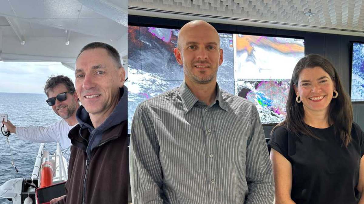
The primary driver of this operational evolution is the deployment of operational long-range marine heatwave forecasting, engineered collaboratively by the Commonwealth Scientific and Industrial Research Organisation (CSIRO) and the Australian Bureau of Meteorology (BoM). Developed and validated through extensive trial forecasting between 2020 and 2025, this capability earned national recognition as a finalist and winner of the 2026 Department of Climate Change, Energy, the Environment and Water Eureka Prize for Environmental Research. Led by Dr Alistair Hobday and Jason Hartog of CSIRO, alongside Dr Claire Spillman and Grant Smith of the Bureau of Meteorology, the team delivered Australia’s first operational seasonal forecasting service for extreme ocean temperatures.
Prior to this technological advance, marine park managers and commercial operators relied on short-range sea surface temperature forecasts that provided only days or a few weeks of operational visibility. The CSIRO-BoM predictive system extends this operational window to four months—equivalent to 120 days of advance notice—projecting the likelihood, geographic coordinates, and severity of impending marine heatwaves.
Updated three times weekly on the Bureau of Meteorology portal, the system categorises regional ocean warming using four standardized tiers: Moderate, Strong, Severe, and Extreme. These classifications communicate complex coupled ocean-atmosphere dynamics in an accessible format for decision-makers across coastal sectors.Dynamic Forecast Metric Technical Specification Operational Impact for Tourism Authorities Forecasting Horizon Up to 120 days (four calendar months) advance outlook Enables 90- to 120-day marketing and itinerary scheduling windows Data Update Frequency Three updates per week via dedicated national web portal Provides near-real-time validation of emerging regional thermal anomalies Spatial Extent Sovereign Australian exclusive economic zone and Coral Sea basin Pinpoints sub-regional marine park management sectors and outer reefs Hazard Categorisation Moderate, Strong, Severe, and Extreme heatwave tiers Standardises biological risk thresholds across state and national agencies Underlying Modelling Coupled ocean-atmosphere dynamical seasonal prediction systems Translates atmospheric oscillations into localized benthic temperature trends Governance Interfacing Direct ingestion into state and Commonwealth marine response plans Triggers statutory pre-event conservation actions across jurisdictions
The practical value of this forecasting advance lies in its capacity to drive operational readiness. When announcing the nationwide rollout, Federal Minister for the Environment and Water Murray Watt highlighted the strategic importance of anticipatory environmental planning:
“Marine heatwaves were listed as a key hazard in the National Climate Assessment, and we expect them to become more common due to climate change. Recent extreme marine heatwave events have had serious impacts on ocean health, protected species, and fisheries and aquaculture operations in Australian waters… These forecasts will help prepare for water temperature heatwaves.”
CSIRO Chief Research Scientist Dr Alistair Hobday emphasized how early risk awareness transforms ecological decision-making:
“Information about the future can support decision making. Marine heatwave forecasting tells you how you might be loading the dice for a range of ecological impacts. What marine heatwave forecasting can provide is the opportunity to develop rapid responses before events occur. Over the past five years, this project has shown how a strong relationship between CSIRO and the Bureau of Meteorology can result in world-leading scientific breakthroughs. But it’s the connection we developed with the forecast users that has created the real-world impact and is also helping the long-range game – adapting to climate change.”
For commercial operators, receiving verified notification in October that the Coral Sea or northern Great Barrier Reef will encounter Moderate to Severe heatwave conditions through February completely reconfigures the annual business cycle. Instead of facing unexpected disruptions, operators utilize the four-month buffer to structure dedicated participatory eco-tourism innovations, aligning operational capacity directly with ecological monitoring priorities.
Commercialising a four-month ocean forecast requires rethinking customer acquisition, operational staging, and tour pricing structures. Traditional citizen science programs in coastal tourism have historically functioned as incidental activities—an optional mobile application download or an informal evening slide presentation offered during a leisure charter. Consequently, customer acquisition operates on compressed booking cycles of two to four weeks, appealing primarily to casual snorkelers seeking passive sightseeing.
In contrast, predictive conservation travel structures commercial itineraries directly around the 120-day forecasting window. Once the CSIRO-BoM models detect an emerging thermal anomaly, charter companies possess the runway needed to market specialised “Marine Climate Emergency Expeditions”. Far from dampening booking interest, validated industry data shows that eco-conscious travelers actively seek immersive field opportunities where their physical presence and financial investment contribute to ecosystem defense during acute climate events.
The commercial viability of this approach is supported by distinct pricing power. Participatory conservation itineraries regularly command premiums of 15% to 35% above standard leisure dive charters. This yield premium reflects clear operational differentiators:
| Operational Parameter | Conventional Leisure Dive Charters | Predictive Conservation Expeditions | Strategic Business and Ecological Benefit |
| Booking Horizon | 14 to 30 days prior to departure | 90 to 120 days prior to departure | Triples forward cash flow visibility and logistics planning |
| Pricing Baseline | Standard retail leisure pricing | 15% to 35% premium over leisure charters | Generates higher margins while offsetting specialist staffing costs |
| Pre-Departure Regimen | Basic liability waivers and medical forms | Comprehensive multi-module digital training | Arrives on-site with competent, certified survey teams |
| Survey Methodology | Ad-hoc, unverified recreational sightings | Standardized benthic quadrats and transects | Yields peer-reviewed, decision-grade ecological data |
| Regulatory Impact | Negligible management utility (<5% logged) | Over 300% surge in verified data logs | Multiplies spatial monitoring coverage for park rangers |
| Asset Contribution | Passive recreational footprint | Active pest removal and nursery outplanting | Generates measurable net-positive ecological restoration |
This advance operational runway directly resolves the central limitation faced by public conservation managers: personnel deficits across extensive marine protected areas. During widespread thermal stress events, sovereign park agencies lack the maritime vessels and scientific dive staff required to survey thousands of dispersed reefs.
By mobilizing pre-trained tourist survey teams into forecast-targeted coordinates, citizen science travel programs expand monitoring capacity. Submissions through national statutory monitoring platforms increase by over 300% during forecasted events, effectively converting paying visitors into an organized field workforce for government authorities.

Image generated with Ai
The institutionalization of visitor-led science is exemplified within Australia’s Great Barrier Reef Marine Park, managed by the Great Barrier Reef Marine Park Authority (GBRMPA). Through its established destination stewardship frameworks, the authority maintains a structured data collection hierarchy that translates amateur underwater observations into robust management metrics.GBRMPA Multi-Tiered Data Collection Hierarchy Description 1. Sightings Network (General Visitors) Universal mobile app for logging opportunistic geo-tagged sightings of wildlife or coral bleaching events 2. Rapid Monitoring (Eco-Tourists) Six online training modules teaching divers standardised benthic cover assessments and bleaching identification tags 3. Tourism Weekly (Charter Operators) Long-term monitoring programme requiring 40+ annual repeat site surveys to assess spatial ecosystem trends 4. Reef Health & Impact Surveys (RHIS) Highly rigorous 5-metre radius circular transects covering 78.5 m² to quantify coral mortality and reef impacts
The GBRMPA framework organizes public participation across progressive tiers of technical complexity:
The entry-level Eye on the Reef Sightings Network functions as a crowd-sourced intelligence tool. Utilizing a free, GPS-enabled smartphone application, any tourist or commercial crew member can submit geo-referenced imagery of marine wildlife, pest outbreaks like Crown-of-Thorns Starfish (COTS), or early signs of thermal bleaching. These visual records stream into GBRMPA spatial databases, functioning as an automated tripwire that alerts managers to emerging localized impacts.
For participants aboard dedicated high-yield conservation tours, the Rapid Monitoring Survey represents the primary operational protocol. Divers and snorkelers complete six online training modules covering reef ecology, benthic classification, and coral health diagnostics, with each unit concluding in a formal knowledge assessment. In the water, trained guests record benthic composition, estimating hard coral, soft coral, and macroalgae cover alongside specific bleaching indices along defined transect lines. With over 460 comprehensive Rapid Monitoring surveys submitted annually, this protocol delivers a continuous stream of standardised health observations across key tourism catchments.
The most rigorous tier is the Reef Health and Impact Survey (RHIS), designed for advanced citizen scientists, conservation staff, and commercial dive masters. Requiring more than five hours of foundational technical training, the RHIS methodology assesses reef condition within a series of circular survey areas with a five-metre radius, covering 78.5 square metres each. Within these defined plots, divers record absolute counts of coral colonies, visible disease lesions, structural breakage, predation scars, and heat-induced mortality. This method generates high-integrity data that feeds directly into official Marine Park Reef Health Updates.
Underpinning this data integrity is the Master Reef Guides initiative, delivered through a partnership between GBRMPA, the Association of Marine Park Tourism Operators (AMPTO), and Tourism and Events Queensland. Master Reef Guides complete rigorous training encompassing reef biology, dynamic oceanography, cultural heritage, and field communication. Working aboard vessels operated by companies such as Coral Expeditions, Ocean Rafting, and Reef Biosearch, these guides supervise guest survey activities, ensuring that data gathered by fee-paying travelers meets strict regulatory standards.Oceania Marine Tech & Citizen Science Innovations Description 1. Edge-AI Electronic Vessel Tracking (Pacific Islands) Real-time onboard AI monitoring for small charter boats across Pacific Small Island Developing States (Fiji, Palau) to track illegal fishing near dive sites while guests record wildlife observations 2. AI Coral Bioacoustics & Smart Buoys (Australia & New Zealand) Underwater hydrophone arrays used in Australia and New Zealand, enabling tourists to record reef soundscapes and measure ecosystem recovery after marine heatwave events 3. Indigenous Traditional Knowledge Systems (Fiji & Vanuatu) Combines satellite-based heatwave forecasts with local customary fishing calendars and Tabu conservation zones to guide sustainable eco-tourism itineraries
The financial justification for this data collection architecture is reinforced by sovereign asset valuations. An independent assessment by Deloitte Access Economics calculated the total economic, social, and icon asset value of the Great Barrier Reef at A$56 billion [cite: 3, 4]. The ecosystem supports more than 64,000 direct and indirect full-time jobs and contributes A$6.4 billion annually to Australia’s national economy, outpacing many domestic manufacturing and mining industries. With tourism alone generating A$29 billion of that economic asset base, deploying early-warning analytics and visitor monitoring to defend reef integrity directly protects national economic capital.
The integration of marine predictive intelligence into visitor management is expanding across the wider Pacific basin. For Pacific Small Island Developing States (SIDS), marine ecosystems represent the structural core of national gross domestic product, community subsistence, and cultural identity. However, these island territories face severe climate exposure: projections indicate that under moderate emissions scenarios, Pacific archipelagos will experience over 100 marine heatwave days annually by 2050, threatening reef survival and coastal tourism viability.
To address this challenge, the Australian Government, through the Department of Foreign Affairs and Trade (DFAT), funded the Climate and Oceans Support Program in the Pacific (COSPPac), committing more than AU$59 million across successive phases. Developed collaboratively by the Bureau of Meteorology, the Pacific Community (SPC), and the Secretariat of the Pacific Regional Environment Programme (SPREP), the initiative created the Pacific Ocean Portal.
Operating as an integrated decision-support platform, the portal supplies 14 Pacific Island nations—including Fiji, Palau, Vanuatu, Samoa, and the Solomon Islands—with localized oceanographic data. Designed to function reliably over low-bandwidth telecommunications networks, the portal combines near-real-time satellite altimetry, sea surface temperature anomalies, wave conditions, and long-range coral bleaching alerts into a user-friendly interface.
National Meteorological Services and provincial tourism boards utilize these tools to operationalize predictive conservation programs tailored to local coastal environments:
The Republic of Palau set an international benchmark for sovereign conservation by designating 80% of its Exclusive Economic Zone—spanning approximately 500,000 square kilometres—as the no-take Palau National Marine Sanctuary. Enforcing compliance across this expansive marine area requires innovative technology. Through bilateral partnerships and modernized surveillance infrastructure, Palau integrated Vessel Monitoring Systems (VMS) with Edge-AI electronic vessel monitoring systems on domestic fishing and tour vessels.
These surveillance assets operate alongside tourism stewardship initiatives. Every international visitor entering the country must sign the Palau Pledge, an immigration policy stamped directly into passports that legally requires travelers to act with environmental responsibility under customary conservation laws (Bul). Small-scale charter vessels are equipped with onboard tracking units, allowing dive operators and paying guests to act as monitoring sentinels. While eco-tourists log wildlife biodiversity encounters on mobile tablets, onboard edge processors log vessel transponder pings, alerting authorities to unauthorized commercial fishing incursions along sanctuary boundaries.
Across Fiji’s Mamanuca and Yasawa archipelagos, resort operations and indigenous coastal communities have integrated regional ocean alerts into proactive reef stewardship. Drawing on the Pacific Ocean Portal’s seasonal thermal forecasts, resort marine biology units track approaching heatwave risks.
When anomalous heating threatens shallow coastal waters, operators adapt guest dive itineraries toward preventative biological interventions. Visitors are deployed on coordinated Crown-of-Thorns Starfish culling sweeps, removing coral-consuming predators from outer reef walls prior to thermal events to alleviate compounding ecological stress. Concurrently, travelers assist in transferring nursery-grown coral fragments from vulnerable shallow flats to deeper passages cooled by ocean currents, protecting genetic parent stock through the peak warming season.
In French Polynesia, the non-profit restoration organization Coral Gardeners, founded on Moorea, created CG Labs to develop ReefOS—an open-architecture digital monitoring platform powered by artificial intelligence.
The system pairs solar-powered oceanographic buoys with underwater optical arrays that continuously measure temperature, turbidity, and light penetration. Machine learning algorithms process benthic photography to automate calculations of coral growth, tissue mortality, and three-dimensional structural volume. Participating eco-tourists assist in outplanting nursery fragments, assigning unique digital identifiers to restored colonies via mobile software, and tracking the growth and thermal survival of their corals through real-time, automated sensor data.Geographic Destination Sovereign Agency / Initiative Core Climate Tech Integration Visitor-Led Conservation Role Queensland, Australia GBRMPA & Bureau of Meteorology CSIRO 120-day ocean outlooks; Eye on the Reef platform Rapid Monitoring Surveys, RHIS benthic assessment, COTS tracking Republic of Palau Ministry of Agriculture, Fisheries & Environment Edge-AI vessel tracking; automated National Monitoring Center Sanctuary boundary monitoring, Palau Pledge ecological audits Fiji (Mamanuca / Yasawa) Pacific Community (SPC) & SPREP Pacific Ocean Portal seasonal SST and bleaching models Pre-heatwave COTS culling, deep-water nursery outplanting Moorea, French Polynesia CG Labs / Coral Gardeners ReefOS computer vision and multi-sensor telemetry buoys High-density nursery planting, fragment tagging, 3D growth audits New Zealand (Hauraki Gulf) Department of Conservation / NIWA Passive acoustic hydrophones and automated bioacoustic CNNs Soundscape baseline logging, biophony recovery surveys
While visual quadrat surveys remain a cornerstone of marine monitoring, the deployment of underwater passive acoustic monitoring (PAM) and artificial intelligence bioacoustics offers an objective, non-invasive dimension to citizen science itineraries. Healthy marine habitats generate complex acoustic soundscapes defined by three distinct components: biophony (sounds produced by living organisms), geophony (natural non-biological sounds such as waves, wind, and rain), and anthropophony (underwater noise generated by human activity, including maritime shipping and vessel engines).
In tropical coral reef systems, biophony is dominated by two primary frequency bands:
First, snapping shrimps (Alpheidae) generate a persistent broadband acoustic crackle between 1.5 kHz and 5.0 kHz through the cavitation bubbles created by their modified claws. This ambient soundscape reflects the structural complexity of the benthic framework. Second, soniferous teleost fishes produce acoustic pulses, croaks, and grunts concentrated between 100 Hz and 1,000 Hz—such as damselfish vocalizations clustered around 400 Hz—which correspond to courtship, spawning rituals, and territorial disputes.
Collectively, this underwater biophony forms an acoustic signal that propagates across tens of kilometres of open ocean, providing a sensory cue that pelagic larvae and juvenile fishes use to navigate toward healthy reef habitats for settlement.
When a severe marine heatwave triggers mass bleaching and subsequent coral mortality, this soundscape deteriorates rapidly. As resident fishes migrate or perish and cryptic invertebrates decline, biophonic amplitude collapses, leaving an acoustic void that discourages larval recruitment and slows natural regeneration. Conversely, as structural restoration proceeds, biophonic diversity returns long before slow-growing hard corals achieve macroscopic coverage.
To measure these dynamics, specialized dive charters in Queensland and New Zealand provide guests with calibrated SoundTrap autonomous hydrophone units. During survey dives, participants anchor hydrophone arrays across designated reef zones to record pristine acoustic snapshots. Back aboard the vessel, guests process raw audio files through machine learning tools that compute standardized ecological indices.
By calculating the Normalized Difference Soundscape Index (NDSI), alongside the Acoustic Complexity Index (ACI) and Bioacoustic Index (BI), citizen scientists assess habitat health over time. In New Zealand’s coastal reserves, where community groups are restoring degraded rocky urchin barrens into flourishing kelp forests, visiting divers deploy hydrophones to benchmark returning fish vocalizations. This participatory approach supplies marine researchers with dense acoustic datasets that would be financially prohibitive to collect through academic dive expeditions alone.
Technological advances in satellite telemetry and hydrodynamic modelling are most effective when integrated with customary ecological governance. Across Melanesia and Polynesia, coastal indigenous communities have managed marine resources for generations through customary marine tenure systems. In nations like Fiji and Vanuatu, this takes the form of the Tabu—a legally recognized closure declared by traditional chiefs that places temporary, seasonal, or spatial moratoriums on fishing across designated reefs to allow depleted stocks to recover.
Historically, Tabu closures were enacted based on generational ecological calendars, keyed to changes in weather patterns, seasonal flowering cycles, and observed fish spawning aggregations. Today, progressive eco-resorts, non-governmental organizations, and provincial councils in Oceania are linking sovereign satellite forecasts directly with traditional leadership structures.
When the Pacific Ocean Portal projects elevated thermal stress across an island group, local chiefs (Turaga ni Koro) and village councils can declare precautionary Tabu closures over vulnerable fringing reefs months before bleaching commences. Commercial dive operators actively support these customary declarations. Rather than taking visitors into thermally stressed shallow lagoons—where anchor use, accidental fin strikes, and swimmer resuspension of sediment can accelerate coral mortality—charter captains redirect vessels toward perimeter management activities.
Under the direct supervision of indigenous marine guides, visiting divers perform targeted conservation tasks:
By respecting customary closures, predictive conservation travel fosters collaborative relationships between visitors and host communities. Conservation fees and diving levies collected from high-yield participants flow directly into community trust accounts, providing financial compensation for local fishers during moratorium periods. This economic alignment validates proactive stewardship, ensuring local communities are not forced to compromise long-term conservation for immediate economic survival during climate stress events.
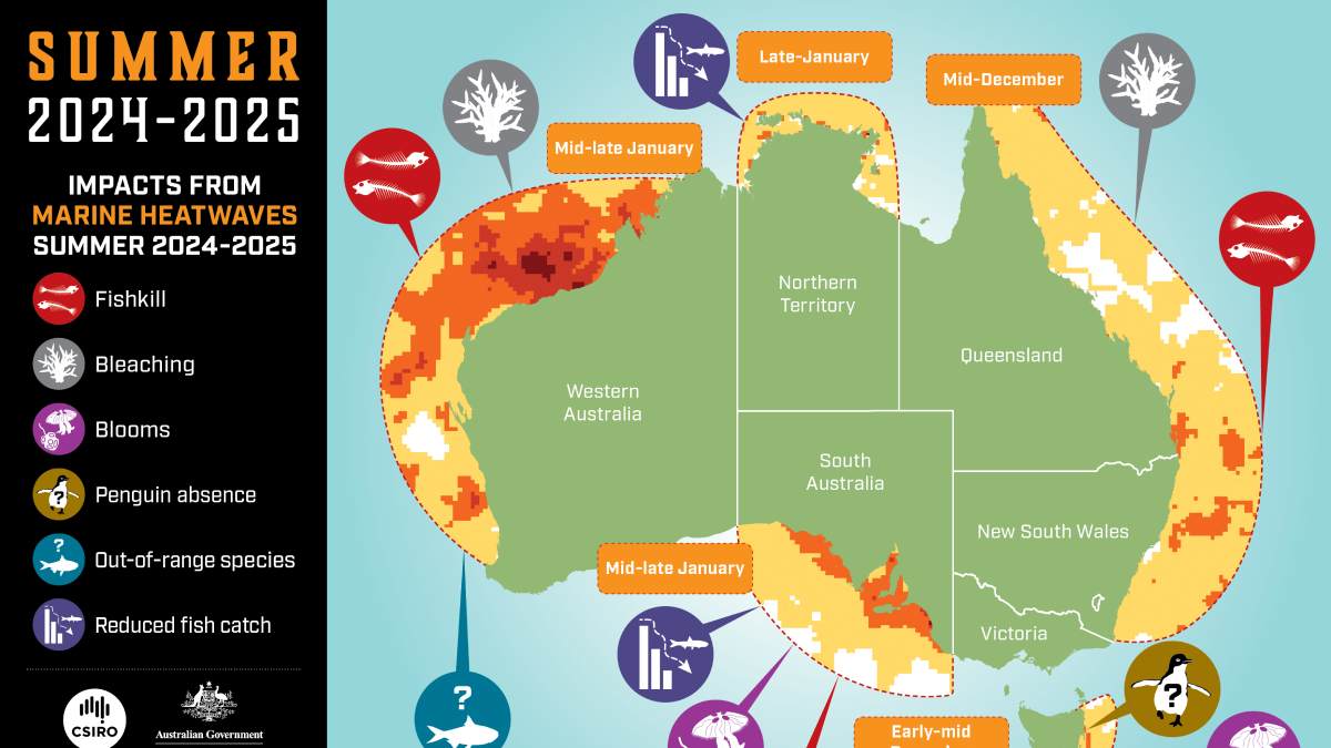
Image generated with Ai
The application of predictive marine data is fundamentally transforming resort underwriting, coastal infrastructure investment, and property insurance throughout Oceania. Coral reefs function as natural breakwaters for coastal infrastructure, luxury real estate, and low-lying island communities. A structurally intact, complex reef can dissipate up to 97% of incident wave energy before it reaches the shoreline, preventing beach erosion, reducing storm surge impact, and protecting resort developments from catastrophic wave action during tropical cyclones.
Historically, real estate developers and commercial lenders treated extreme marine events as uninsurable natural hazards. Traditional indemnity insurance models proved ill-suited for nearshore marine ecosystems: verifying sub-surface biological damage after a severe storm requires expensive underwater surveys, and claim adjustments frequently take 12 to 24 months to resolve—long after detached coral fragments have died from sediment smothering.
To resolve this liquidity lag, global reinsurance brokers and development finance institutions designed parametric reef insurance. Unlike traditional indemnity coverage, parametric policies disburse pre-agreed payouts automatically when an independently verified environmental parameter exceeds a specified threshold—such as wind speeds surpassing Category 3 intensity within an agreed geographic area, or sea surface temperatures maintaining elevated Degree Heating Weeks (DHW) beyond critical biological limits.Insurance Policy Dimension Traditional Indemnity Property Insurance Parametric Natural Asset Insurance Operational Benefit for Marine Destinations Claim Trigger Mechanism Proven physical asset damage validated by on-site loss adjusters Objective data parameter exceeded (e.g., wind speed or SST index) Eliminates prolonged claims disputes and bureaucratic delays Settlement Horizon Six to 24 months following complex litigation and audits Ten to 14 days directly into designated restoration trust accounts Delivers rapid capital to deploy divers while corals are salvageable Covered Asset Scope Built onshore infrastructure (villas, jetties, seawalls) Natural barrier infrastructure (coral reefs, barrier mangroves) Directly finances the repair of nature-based defensive assets Deployment Mechanism Capital allocated to contractor rebuilding and civil works Funds emergency Reef Brigades and community first responders Mobilises pre-trained citizen science divers and local guides Underwriting Verification Retrospective visual appraisal and engineering inspections Independent satellite telemetry and verified meteorological indices Removes verification bias through transparent scientific criteria
A landmark implementation of this financial architecture occurred in Fiji’s northern Lau archipelago. Developed by insurance broker WTW with capital support from BHP and underwritten by the Pacific Catastrophe Risk Insurance Company (PCRIC), the policy provides up to US$450,000 in immediate coverage for reef ecosystems and community assets across Vatuvara Island, Yacata, and Kaibu Island (home to the luxury Vatuvara Private Islands Resort).
The operational advantage of parametric financing is speed. Payouts are transferred within ten to fourteen days of a qualifying event, providing immediate funding when physical intervention is most effective. These funds finance the immediate deployment of specialized “Reef Brigades”—response teams comprising resort marine biologists, indigenous village divers, and certified visiting citizen scientists.
Equipped with rapid-setting underwater cements and restoration matrices, these response teams deploy within days of a storm passing, righting overturned coral heads, securing loose structural fragments, and clearing sediment before mortality sets in.
For coastal hospitality developers, integrating predictive monitoring and trained response teams yields tangible balance sheet advantages:
Properties demonstrating active eco-monitoring, automated sensor infrastructure, and certified on-site response brigades negotiate lower property insurance premiums from international underwriters. Concurrently, commercial banks and institutional development funds view proactive natural asset protection as a risk-mitigation factor, unlocking access to discounted green financing for resort construction. Furthermore, by converting guest activities into subsidized emergency restoration itineraries, resorts maintain visitor occupancy and preserve marine tourism jobs during post-event recovery windows.
The operational utility of marine heatwave forecasting extends beyond dive charters into coastal food systems and blue gastronomy. Food and seafood tourism represents a rapidly growing component of Oceania’s visitor economy, with high-spending travelers seeking authentic culinary trails, wild-catch experiences, and native marine delicacies.
However, severe ocean warming poses acute risks to coastal fisheries and aquaculture operations. Prolonged marine heatwaves induce rapid biological disruptions: water stratification leads to benthic hypoxia, pathogenic marine bacteria like Vibrio proliferate, and harmful algal blooms (HABs) trigger shellfish toxicity and mass mortalities across aquaculture leases.
For resort culinary directors, commercial seafood operators, and food tour organizers, the four-month advance outlook provided by the Bureau of Meteorology and CSIRO provides a vital planning buffer. Historically, unexpected marine heatwaves forced emergency seafood cancellations, disrupted regional culinary trails, and created significant food safety liabilities.
With 120 days of advance warning, hospitality managers execute strategic operational shifts:
Executive chefs reconfigure seasonal menus well ahead of projected heatwaves, substituting vulnerable nearshore shellfish with resilient offshore pelagic species or products from certified land-based recirculating aquaculture systems (RAS). Concurrently, culinary itineraries pivot toward climate-resilient native species, introducing guests to dishes featuring endemic seaweeds, sustainable macroalgae, and locally harvested invasive species like sea urchins gathered during reef-clearing initiatives.
Furthermore, luxury eco-resorts are integrating culinary tourists directly into the stewardship of coastal food webs. Guests take part in hands-on aquaculture experiences, assisting marine biologists in seeding native rock oyster reefs or outplanting juvenile giant clams (Tridacna) into protected lagoon nurseries. These bivalve systems enhance local water clarity through biological filtration, mitigate coastal erosion, and support juvenile fish populations, turning culinary travel into an active contributor to coastal food security.
The rapid operationalization of marine climate forecasting across Oceania provides a practical roadmap for international climate adaptation and marine park management. Profiled by the World Meteorological Organization (WMO) and highlighted in leading scientific literature, Australia’s integration of ocean forecasting with end-user marine sectors establishes a model for global blue economy governance.
To capitalize on these operational innovations, governments and regional tourism bodies are advancing key policy adjustments:
First, marine park agencies are developing formal statutory mechanisms to integrate certified citizen science data directly into official state-of-the-environment accounting. By employing standardized verification algorithms, authorities validate and ingest high-density diver observations into sovereign management databases, addressing public monitoring deficits through organized private-sector execution.
Second, sovereign environmental taxation is evolving to incentivize active stewardship. Regulatory bodies are considering fee structures that offer rebates on levies, like Australia’s Environmental Management Charge (EMC), for commercial operators that deliver accredited citizen science expeditions and submit validated survey data. This fiscal model rewards active environmental monitoring while discouraging passive, high-impact tourism.
Third, multilateral development initiatives, modeled on Australia’s COSPPac program, are expanding scientific capacity across developing island states. Broadening access to high-resolution ocean monitoring networks ensures that regional archipelagos possess the predictive tools required to protect natural resources, underwrite parametric insurance facilities, and support coastal livelihoods.
By applying predictive environmental science to commercial operations, Oceania has demonstrated that marine tourism need not remain a passive victim of ocean warming. Through the synthesis of seasonal ocean models, accredited citizen science, customary indigenous management, and innovative parametric insurance, the region has engineered an effective operational model for predictive conservation travel. In this proactive framework, the visiting eco-tourist moves beyond the role of an extractive spectator, serving instead as a trained and capable contributor to marine conservation across our most vulnerable ocean environments.
The emergence of predictive hydrodynamic intelligence represents a structure shift in Oceania that makes destination stewardship a fundamental operational norm. The connection of heat wave forecasting with proven citizen science enables marine tour companies to move beyond mere leisure activities. Predictive conservation travel ensures that global divers become effective environmental first responders by filling huge knowledge gaps in marine reserves as well as producing better financial gains. With increasing thermal stress events around the world, the fusion of indigenous customary governance, edge electronic vessel tracking and parametric risk underwriting provides a replicable framework for climate resilient tourism.
Advertisement
Advertisement
Advertisement













Friday, September 4, 2026

Friday, September 4, 2026

Friday, September 4, 2026

Friday, September 4, 2026

Thursday, September 3, 2026

Wednesday, September 2, 2026

Friday, September 4, 2026
Friday, September 4, 2026


