
Reykjavik Aligns with Naples and More to Transform Geotourism as Europe Uses AI Rerouting and Smart Insurance to Tackle Seismic Swarms

Published
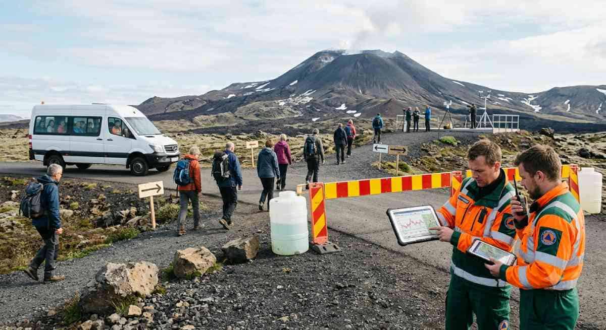
Continuing geologic unrest in Europe’s active rift valleys has necessitated a shift in the management of destination safety and business risk. With the testing of geotourist sites by volcanic seismic activity in areas ranging from Iceland to Italy, the cost of emergency response systems is economically unsustainable. Governments and tour providers utilize predictive travel routing algorithms along with automatic financial protection plans. The use of real-time geologic telemetry connected to parametric insurance allows for the transformation of tectonic disruptions into operational planning within the European tourism industry.
Managing Volcano-Seismic Swarms Across European Geotourism Corridors
Tectonic Vulnerabilities and the Limits of Conventional Travel Management
The tectonic architecture of the European continent is defined by active deformation belts where continental collisions, crustal extension, and subduction generate recurring seismic and volcanic phenomena. In the North Atlantic, the divergence of the North American and Eurasian tectonic plates traverses southwest Iceland along the Reykjanes Ridge, driving episodic magmatic rifting episodes marked by intensive fissure swarms and shallow earthquakes. Simultaneously, the convergence of the African and Eurasian plates shapes the geodynamics of Southern Europe, creating an intricate hazardous environment that includes the Hellenic Subduction Arc in Greece, the Campanian volcanic arc and Apennine extensional systems in Italy, and the complex thrust faulting of the Dinaric Alps traversing Croatia and Albania.
For decades, the European tourism sector approached these geologic hazards through binary operational models: destinations were treated as either entirely accessible or completely closed. When seismic activity escalated, the default administrative reaction was the immediate issuance of blanket travel warnings, municipal cordoning, and indiscriminate booking cancellations. While necessary during acute, catastrophic eruptions or massive singular tectonic ruptures, this rigid paradigm proves disastrous during prolonged volcano-seismic swarms. Unlike isolated earthquakes, these swarms manifest as persistent clusters of low-to-moderate magnitude tremors accompanied by surface deformation, subsurface fluid migration, and hydrothermal fluctuations that can endure for months or years without escalating into an explosive climax.
Under traditional operational models, destination management organisations suffered severe economic attrition during swarm crises. Tour wholesalers booked visitors into rigid, non-transferable itineraries that channelled coach convoys through single-access volcanic corridors, creating acute transit bottlenecks during sudden road closures. Concurrently, commercial accommodation relied on centralized booking channels that concentrated guest occupancy within coastal and volcanic epicentres, multiplying evacuation challenges.
Advertisement
Advertisement
Most critically, conventional indemnity insurance products created substantial coverage gaps for hospitality operators. Traditional policies require verifiable physical structural damage or declared civil emergencies to trigger claims processing, leaving businesses entirely unprotected against the financial fallout of non-damage business interruptions caused by precautionary cordons, localized transit restrictions, and reputational cancellations. To break this cycle of economic stagnation, national civil protection authorities, municipal transport planners, and travel providers have pioneered an operational infrastructure founded on dynamic routing and parametric seismic insurance.
Regional Engineering and Dynamic Corridor Realignment in Action
The operationalization of real-time geoscientific data has fundamentally altered the management of European travel corridors, shifting emergency response from reactive retreat to proactive mobility management.
Advertisement
Advertisement
Iceland: Reykjanes Defensive Berms and Secondary Corridor Protocols
The Reykjanes Peninsula in southwest Iceland represents an advanced testing ground for geotourism continuity amidst ongoing magmatic unrest. Beginning in late 2023 and continuing through protracted eruptive episodes along the Sundhnúkur crater row, recurrent magmatic dike intrusions repeatedly threatened municipal centers like Grindavík, vital power infrastructure at Svartsengi, and iconic leisure attractions such as the Blue Lagoon. Rather than paralyzing Iceland’s international travel economy, an integrated civil defence and dynamic routing framework was deployed by the Department of Civil Protection and Emergency Management (Almannavarnir), the Icelandic Meteorological Office (Veðurstofa Íslands), and the Icelandic Tourist Board (Ferðamálastofa).
A central physical pillar of this strategy is the rapid construction of massive defensive earthen berms (varnargarðar) surrounding the Svartsengi geothermal power plant and Grindavík. These engineered barriers, funded through targeted national appropriations, strategically direct basaltic lava flows away from critical infrastructure, protecting the arterial lifelines that connect Keflavík International Airport to the capital metropolitan area.
Operating alongside these physical barriers is an automated transport intervention termed the “secondary corridor” redirection protocol. Icelandic tour operators have integrated the live geophysical telemetry feeds of the Icelandic Meteorological Office directly into their fleet management software. When continuous GPS measurements and seismic rate counters indicate rapid crustal deformation or dike propagation, incoming tour bookings are rerouted within two hours away from the Reykjanes perimeter and into designated secondary corridors.
Travelers scheduled for southwestern volcanic excursions are seamlessly diverted to West Iceland’s Silver Circle—taking in the Borgarfjörður cultural landscape, Deildartunguhver thermal springs, and Hraunfossar—or North Iceland’s Diamond Circle, linking Akureyri, Lake Mývatn, Húsavík, and Dettifoss. Simultaneously, ground transport shuttles operating between Keflavík International Airport and Reykjavík utilize live highway sensor networks, automatically rerouting airport passenger transfers onto pre-surveyed secondary distributor highways whenever primary routes encounter localized civil protection cordons, maintaining uninterrupted air transit operations.
Southern Italy: Bradyseismic Urban Decentralisation and Aviation Ash Relays
In Southern Italy, the Phlegraean Fields (Campi Flegrei)—a large volcanic caldera west of Naples—presents an intricate logistical challenge due to the phenomenon of bradyseism (bradisismo), which causes slow, cyclical vertical ground displacement driven by hydrothermal and magmatic system dynamics. During active phases, this ground uplift generates frequent, shallow seismic swarms directly beneath dense urban settlements including Pozzuoli, Agnano, and Bagnoli. Comprehensive technical evaluations across civil protection networks were prompted by significant unrest in the region, including an earthquake and associated seismic swarm on 31 July 2026.
To address these vulnerabilities without shutting down regional tourism, landmark structural measures were enacted by the Italian Government, including Decreto-legge n. 140/2023 (converted into Law 183/2023) and Decreto-legge n. 91/2024. Multi-million-euro budgets were allocated by these legislative interventions to implement extraordinary seismic vulnerability analyses across private and public infrastructure, expand 24/7 seismic monitoring arrays, and regulate urban density by restricting building authorizations within high-risk intervention zones.
Advertisement
Advertisement
In alignment with these legislative directives, the “Inland Campania Bypass” was established by regional tourism authorities and commercial operators. Utilizing near-real-time ground motion parameters, spectral response figures, and expected ground shaking maps generated by the National Institute of Geophysics and Volcanology’s Vesuvius Observatory (INGV-Osservatorio Vesuviano), visitor concentrations are actively decentralized by tour providers.
Whenever seismic swarms intensify under Yellow Alert (Allerta Giallo) conditions, travel groups are rerouted away from congested coastal routes in Pozzuoli and dispersed toward inland Campania. Heritage tours are directed to inland UNESCO World Heritage sites, such as the monumental complex of Santa Sofia in Benevento and the Royal Palace of Caserta. This proactive diversion mitigates urban bottleneck risks along evacuation routes while preserving the regional tourism economy.
Simultaneously, in eastern Sicily, Mount Etna introduces operational friction through explosive paroxysms that generate high-altitude volcanic ash plumes. When ashfall forces the closure of runways at Catania–Fontanarossa Airport, intermodal aviation buffers are activated by regional transport operators. Rather than cancelling thousands of incoming and outgoing flights, passengers are diverted to Comiso Airport or Falcone Borsellino Airport in Palermo by automated regional ground coach networks, redistributing passenger traffic across Sicily’s multi-hub transport network.
The Aegean Arc: Submarine Swarm Surveillance and Insular Evacuation Infrastructure
The Hellenic Volcanic Arc across the southern Aegean Sea is dominated by the Santorini caldera complex and its submarine neighbor, the Kolumbo volcano, situated 6.5 kilometres northeast of Cape Kolumbo. Submarine seismic swarms along the Santorini-Amorgos fault zone have prompted joint operational interventions by the Greek Ministry of Climate Crisis and Civil Protection and the Earthquake Planning and Protection Organisation (OASP).
Under the national emergency management doctrine—anchored by the general civil protection plan Xenocrates and the volcanic response plan Thalos—the local operational framework, Thiras 2, was updated by the Municipality of Thira. The island of Santorini is divided by this plan into eight distinct emergency sectors, mapping out specific evacuation staging facilities, dedicated shelters, and maritime extraction embarkation points.
To protect geotourism operations during periods of swarm activity, precise operational safety rules are enforced by Greek authorities:
Advertisement
Advertisement
- Access to hazardous cliffside paths, unstable caldera slopes, and unreinforced stone structures prone to cosismic rockfalls is restricted.
- Private construction and heavy scaffolding along the western caldera rim are halted to prevent destabilizing vibrations and overburdening.
- Maritime tour boarding is restricted at vulnerable docks such as Ammoudi, Armeni, and the Old Port of Fira, with commercial marine transit being consolidated through the primary port of Athinios during strictly regulated scheduling windows.
- Plans for an auxiliary emergency escape port on Santorini’s eastern flank are progressed to ensure independent maritime departure capabilities away from steep caldera switchback roads.
In parallel, dynamic maritime routing informed by the SANTORY seafloor observatory and the Geodynamic Institute of the National Observatory of Athens (NOA-GI) is deployed by commercial ferry companies and Aegean cruise operators. If undersea seismicity spikes within the Kolumbo graben, ferry routes are algorithmically adjusted to substitute port calls at nearby Cycladic islands like Paros, Naxos, or Heraklion in Crete, maintaining maritime booking continuity without entering localized exclusion zones.
The Dinaric Fault: Masonry Preservation and Smart Staging Across Dubrovnik
Across the Western Balkans, the Dinaric Alps fault system poses an ongoing seismic challenge to historic Adriatic destinations, most visibly the UNESCO World Heritage Old City of Dubrovnik in Croatia. Dubrovnik’s architectural identity is characterized by unreinforced stone masonry buildings that are vulnerable to seismic shear forces and structural fatigue during repeated micro-tremors.
In alignment with national risk documentation published by the Croatian Directorate of Civil Protection (Ravnateljstvo civilne zaštite), smart visitor-staging mechanisms linked to seismic hazard thresholds have been introduced by municipal authorities. Visitor densities along the central Stradun are continuously monitored by digital entry gates at the Pile and Ploče gates. During swarm sequences, pedestrian intake is automatically restricted to prevent crowding in narrow medieval corridors that could hinder emergency egress. Concurrently, tour groups are redistributed to modern hotels situated along the Lapad Peninsula and the wider Dubrovnik-Neretva county by regional hospitality consortia utilizing automated inventory-sharing networks, safeguarding historic masonry structures while maintaining regional guest volume.
Financial Engineering: Parametric Seismic Insurance and Algorithmic Underwriting
While physical engineering and rerouting secure operational transit, financial engineering has transformed how the European geotourism value chain absorbs the financial impact of volcano-seismic swarms. The cornerstone of this financial transformation is the rapid adoption of index-based parametric seismic insurance.
| Feature / Metric | Traditional Travel Indemnity Policy | Parametric Seismic Insurance |
| Trigger Mechanism | Verifiable physical structural damage to property or declared civil emergency | Objective physical index breach (e.g., Magnitude, Peak Ground Acceleration, ShakeMap MMI) |
| Settlement Window | 30 to 180 days post-event following on-site loss adjustments | Instantaneous to 72 hours via automated algorithmic disbursement |
| Claims Documentation | Extensive receipts, engineering damage surveys, and forensic audits | Fully automated; zero paperwork required from the policyholder |
| Coverage Scope | Physical asset destruction and limited standard business interruption | Non-Damage Business Interruption (NDBI), guest relocation, precautionary cancellations |
| Basis Risk Profile | Low basis risk (payout matches assessed physical losses post-deductibles) | Higher basis risk (payout tied to index threshold, not direct individual loss) |
The Mechanics of Index-Based Triggers and Scientific Oracles
Traditional commercial insurance fails to address the unique realities of volcanic and seismic swarms because it requires physical asset destruction to unlock business interruption coverage. During a tectonic swarm, tourism enterprises often suffer 80% to 100% drops in booking revenues due to travel warnings and precautionary transit diversions, even when hotels and tour buses remain entirely undamaged. These non-damage business interruptions are routinely excluded under standard indemnity policies. Furthermore, financial delays of three to six months can be created by conventional claims processing requiring manual adjusters, which can bankrupt tourism operators.
Loss adjustment delays are eliminated by parametric insurance models through the establishment of objective criteria governing immediate payout. A claim is triggered whenever a verified physical metric crosses a predetermined threshold within a defined geographic perimeter, often structured via a “Cat-in-a-Box” framework.
Advertisement
Advertisement
To maintain transparency and prevent disputes, underwriting models rely on trusted, independent third-party data oracles. In the European geotourism market, these primary oracles include:
- The European-Mediterranean Seismological Centre (EMSC), providing real-time open-access GeoJSON application programming interface (API) feeds.
- The United States Geological Survey (USGS) Earthquake Hazards Program, supplying ShakeMap instrumental intensity calculations.
- National scientific institutions, such as the Italian National Institute of Geophysics and Volcanology (INGV) and the Icelandic Meteorological Office (IMO).
In practical hospitality applications, tiered step-payout schedules are deployed by underwriters. For example, for a hotel situated within the Phlegraean caldera or along the Santorini volcanic arc:
- Ground motion registering below a baseline threshold produces a 0% payout, reflecting conditions within normal design tolerances.
- Ground motion registering at an initial tier triggers an automated 25% payout, providing rapid liquidity to fund precautionary engineering inspections and immediate guest lounge hospitality.
- Ground motion registering at a moderate tier triggers a 60% payout, covering short-term non-damage business interruption and transport rerouting fees.
- Ground motion exceeding a high-level threshold triggers a 100% full-limit settlement within 72 hours, providing the working capital necessary to execute large-scale guest relocations or navigate prolonged regional closures.
Automated Checkout Integration and Immediate Disruption Liquidity
At the consumer distribution level, parametric “Seismic Disruption Riders” have been embedded directly into digital booking engines by European online travel agencies (OTAs), rail networks, and airlines. When accommodation or a vehicle is booked in designated tectonic corridors by a traveller, a risk-adjusted parametric rider is calculated by a micro-insurance algorithm. Proximity to fault lines, historical swarm frequency, and structural vulnerability are evaluated dynamically via APIs to determine the premium.
If a qualifying seismic trigger is recorded by an independent oracle—such as a specific magnitude event within a set distance or a civil protection transport cordon—the system executes autonomously. Event parameters are verified within seconds by the API, bypassing claims documentation entirely. Pre-agreed cash compensation, alternative inland hotel credits, or airport lounge access passes are transferred directly into the traveller’s digital wallet within hours. Travellers are protected from unexpected expenses by this programmatic liquidity, while small tour operators are shielded from costly booking cancellations and chargebacks.
Macroeconomic Exposure and Multilateral Institutional Frameworks
Significant vulnerabilities across the European travel economy are addressed by the systematic deployment of dynamic transit routing and parametric financial mechanisms, aligning with multilateral disaster risk governance frameworks.
It has been underscored by the European Insurance and Occupational Pensions Authority (EIOPA) that a widening natural catastrophe protection gap is faced by Europe. Historically, only about 25% of economic losses resulting from extreme natural hazards within the European Union were insured, with insurance penetration plummeting to below 5% in vulnerable southern European zones. Compounding this systemic exposure, property catastrophe reinsurance rates across Europe have experienced severe surges. Risk has been systematically reassessed by reinsurance carriers, retention deductibles have been increased, and underwriting exclusions have been implemented for persistent geologic perils such as bradyseismic deformation and volcanic unrest. Comprehensive traditional coverage has often become commercially unfeasible for small- and medium-sized tourism enterprises operating on thin margins.
Advertisement
Advertisement
As highlighted by the Organisation for Economic Co-operation and Development (OECD) in its catastrophe risk governance publications, parametric risk instruments are essential to modern Disaster Risk Financing (DRF). By providing event-contingent capital without administrative friction, liquidity is preserved across vulnerable tourism supply chains by parametric structures.
Policy guidelines established by United Nations Tourism (UN Tourism) are also fulfilled by these operational models. Through its Tourism Emergency Response Network (TERN) and the “Safe Destinations” (Safe-D) framework, member states are urged by UN Tourism to institutionalize transparent data sharing, communicate geographically targeted early warnings, and embed adaptability directly into national destination management plans. As the International Year of Sustainable and Resilient Tourism in 2027 is approached by the international community, global benchmarks for adapting to planetary hazards without triggering economic paralysis are served by Europe’s integration of geoscientific telemetry with commercial travel operations.
Technological Synthesis: The Multi-Layer Geotourism Defense Stack
The successful integration of dynamic routing and parametric underwriting relies on a continuous, four-layer technological architecture that links geophysical sensor networks directly to commercial travel platforms.
| Stack Layer | Primary Infrastructure & Data Protocols | Operational Function | Direct Destination & Commercial Impact |
| Layer 1: Physical Telemetry | Borehole tiltmeters, continuous GNSS arrays, urban accelerometers, ocean-bottom seismometers | Real-time geodetic and seismic waveform data collection | Continuous tracking of surface uplift, fault slip rates, and magmatic migration |
| Layer 2: Algorithmic Triage | Cloud-based ingestion engines, USGS ShakeMap feeds, EMSC GeoJSON APIs | Automated hazard evaluation against predefined safety thresholds | Automatic verification of seismic triggers, generating localized hazard zones and updating civil alerts |
| Layer 3: Dynamic Operations | Tour operator booking platforms, municipal transit feeds, cellular SMS gateways | Algorithmic routing and capacity redistribution | Diversion of tour buses to secondary corridors, intermodal flight relays, and targeted SMS mobile alerts |
| Layer 4: Parametric Settlement | Insurtech smart contracts, banking payment APIs, digital mobile wallets | Programmatic index evaluation and automated fund transfer | Immediate liquidity disbursed to business accounts and digital traveler vouchers issued within hours |
This architecture operates as a closed-loop system:
- Surface and sub-surface telemetry: Continuous data on crustal dynamics is collected by sensor networks deployed across tectonic rifts. Ground inflation is monitored by GNSS stations at Svartsengi and Herdísarvík in Iceland, while ground acceleration waveforms are captured by INGV accelerometers across Pozzuoli.
- Ingestion and threshold analysis: Independent data feeds are ingested by algorithmic analytics engines. When seismic energy releases or ground displacement rates cross defined thresholds, dual operational and financial workflows are triggered by the system.
- Coordinated transport adjustments: Coach itineraries are rerouted toward pre-mapped secondary corridors (such as the Silver Circle in Iceland or the Caserta-Benevento belt in Campania), digital road signs are updated, and replacement inter-airport coaches are dispatched by travel management software.
- Automated financial settlement: Whether event parameters meet the policy’s geographic criteria is independently confirmed by parametric smart contracts. Upon verification, funds are released directly to corporate merchant accounts and consumer mobile wallets, providing instant liquidity to absorb operational shifts.
Future Outlook: Sensor Densification and Machine-Learning Swarm Forensics
As European geotourism continues to evolve, several technological innovations and regulatory initiatives will shape the future of tectonic risk management.
A priority for insurers is mitigating basis risk—the potential mismatch between a parametric policy payout and the policyholder’s actual financial loss. To address scenarios where disruptive ground shaking is experienced by a facility just outside a predefined geometric boundary, a transition is being made by underwriters from simple circular triggers to gridded ShakeMap instrumental intensity maps and on-site Internet of Things (IoT) sensors. By installing tamper-proof accelerometers directly on hotel properties, parametric policies can be triggered based on the exact structural acceleration experienced by the building, virtually eliminating basis risk.
Advertisement
Advertisement
Concurrently, early-warning capabilities will improve as sensor arrays are expanded by national geological agencies. Rich datasets are provided to machine-learning systems through the integration of continuous seismic monitoring, offshore Distributed Acoustic Sensing (DAS) utilizing subsea fiber-optic cables, and satellite Synthetic Aperture Radar (InSAR) ground-uplift imaging. Differentiating between benign hydrothermal fluctuations and shallow magmatic dike intrusions hours before surface fracturing occurs can increasingly be achieved by these AI systems, giving valuable lead time to transport operators and civil protection agencies to adjust transit corridors.
Finally, broader adoption will be supported by regulatory harmonization across the European Single Market. Under oversight from EIOPA, common standards are emerging for index-based insurance products, insurance-linked securities (ILS), and automated digital micro-insurance. Consumers are protected by standardized guidelines, legal clarity is guaranteed for third-party scientific oracles, and unified parametric protection riders can be offered across diverse member states by travel aggregators.
By unifying physical engineering, predictive rerouting, and automated parametric finance into a coherent operational framework, it is demonstrated by the European travel ecosystem that tourism can coexist safely and sustainably with active planetary geodynamics.
Conclusion
An enduring operational standard for contemporary European geotourism is established by the widespread deployment of dynamic rerouting and parametric risk engineering. Rather than physical shifts being treated as an unmanageable catastrophe demanding comprehensive closures by national authorities and commercial operators, they are transformed into disciplined corridor diversions and immediate liquidity releases. Natural volatility is decoupled from severe financial shock by regional stakeholders connecting scientific sensor networks with algorithmic dispatch systems. As active volcano-seismic swarms continue shaping Europe’s iconic tectonic destinations, it is ensured by this proactive technological framework that visitor protection, structural preservation, and destination viability remain robustly sustained throughout protracted geologic cycles without causing economic paralysis.
Advertisement
