

Vietnam’s Dak Nong Geopark Raises the Stakes with Bold Plans for Its UNESCO Review

Published
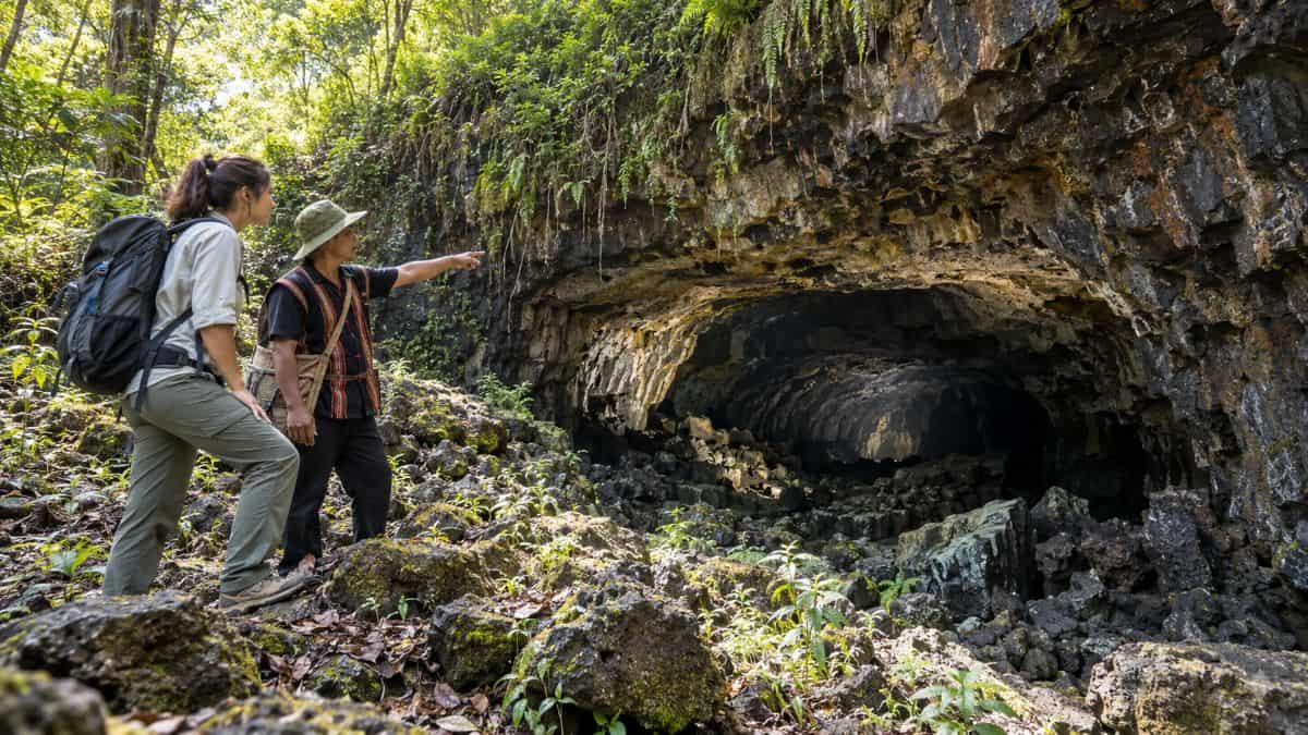
The Dak Nong Geopark in Vietnam is now ready for an assessment that can change the course of its development. Tourists are already coming to see the park because of its caves, waterfalls and volcanic landscape. But the success of the geopark depends upon whether it is able to include the community in its tourist activities. For this purpose, the park administration is now preparing its route system, facilities and administration, which can be inspected by UNESCO experts in 2027. This process will allow the involvement of the residents into the tourist activity. They may tell about the land to tourists and offer their products. But the real test will come later.
A UNESCO Review With Real Stakes for Dak Nong
UNESCO first recognised Dak Nong as a Global Geopark in 2020. The designation was renewed in 2024 through 2027. The next review is expected in June or July 2027, giving local authorities a limited window to prepare.
Advertisement
Advertisement
A review does not simply ask whether an area has striking natural features. UNESCO checks whether a geopark has strong management, protects its important sites, makes them visible to visitors and involves local communities. It also looks at how well the area connects conservation with education and sustainable development. The label is therefore both an honour and an ongoing responsibility.
Dak Nong has already retained its designation once. The current work is preparation for its next assessment, not proof that UNESCO has threatened to remove its status. The story is about how a celebrated destination can keep improving and show that its work benefits the place and its people.
Advertisement
Advertisement
The Volcanic Landscape That Sets Dak Nong Apart
Dak Nong covers about 4,760 square kilometres in western Lam Dong. The area now spans 22 communes and wards, following administrative changes in Vietnam. It includes volcanic landscapes, waterfalls, lakes and sites linked to the history and culture of local communities.
Its most unusual natural feature lies beneath the ground. Dak Nong has South-east Asia’s largest volcanic cave system. It contains around 50 caves and extends for more than 10 kilometres. The lava tubes also hold evidence of volcanic activity and were used as shelter by prehistoric communities thousands of years ago.
Advertisement
Advertisement
The surrounding land tells another part of the story. Volcanic soils support crops such as coffee, tea and rubber. The area also includes the ancestral lands of M’Nong, Ma and Ede communities. This gives Dak Nong the chance to explain how geology shapes daily life, from the ground beneath a farm to the traditions that connect people with their home.
Why Officials Are Rethinking the Visitor Routes
In 2026, officials and experts surveyed three tourism routes and 41 sites. They also looked at organic farms, local products and places that might take part in geopark activities. After the survey, experts proposed reorganising the routes around about 37 stops. The three route themes are “Fire and Water”, “Wind” and “Sound of the Earth”. The proposal may change. It does not mean that four sites have been permanently closed.
The experts said the park should focus on sites it can manage, repair and present well in the time available. They also highlighted safety, site quality and the need for clear responsibility. This is a practical choice. A shorter route with accurate signs and reliable access may give visitors a better experience than a longer list of stops that are difficult to maintain.
For travellers, the key question is what the final routes will offer. Will each stop have clear information? Can visitors understand how the sites connect? Will they know which places are open and how to reach them? Those details can turn a map into a useful travel tool.
Better Visitor Information Could Change the Journey
A geopark can have remarkable attractions and still be hard to explore. Visitors need current maps, directions, opening details and information about local guides. UNESCO identifies visibility as a core feature of geoparks. Residents and visitors should be able to find useful information about the area and the links between its geological and cultural sites.
The new route plan gives Dak Nong a chance to make that information easier to use. A traveller should be able to see how long a route takes, which sites suit a short visit and where to find local services. Information should also explain access limits. The fact that a cave appears in a scientific inventory does not mean that every cave is open to tourists.
Advertisement
Advertisement
Clear information helps protect visitors and heritage sites. It can direct people to suitable locations and explain why certain places need special care. It can also reduce confusion for communities who live near popular attractions.
Hong Kong Shows How Local Stories Can Welcome Visitors
Hong Kong’s UNESCO Global Geopark offers one useful Asian comparison. It has 13 land routes, two boat routes, visitor centres and five community story rooms. These facilities help explain geology, local culture and community history. The geopark also works with local communities on cultural heritage and green tourism.
The lesson for Dak Nong is not that it should copy Hong Kong’s route numbers. The places are different. The useful idea is to make residents part of the visitor experience. A community story room or information point can help visitors understand more than the shape of a rock or the depth of a cave. It can explain how people have lived alongside the landscape.
Experts have proposed five facilities that could receive visitors, display products and provide information. The next step is to make sure that such places do more than direct people onward. They could also give local residents a voice in telling the story of the geopark.
Langkawi Links Local Products With Natural Heritage
Langkawi in Malaysia shows how a geopark can connect tourism with local businesses. Its official programme lists locally made products and participating entrepreneurs for 2024–2027. The products draw on local materials and natural heritage. Examples include coconut-shell crafts, honey from stingless bees, locally sourced rice and batik inspired by the island.
This model makes the link between place and product easy to see. A visitor can learn where an item comes from and why it belongs to the destination. For Dak Nong, that approach could help local products tell a stronger story about the land and its communities.
Advertisement
Advertisement
The province has already looked at farms, organic agriculture and local products as possible parts of its geopark network. But the value of a partnership depends on what happens after it is announced. Are local businesses receiving customers? Do residents earn income? Do products explain the area’s heritage? Those are the results worth tracking.
Satun Shows Why Young People Belong in the Plan
Satun, Thailand, combines a UNESCO Global Geopark with a learning-city programme. Local activities such as Geo Camp help young people explore geology, cultural heritage, sustainable tourism and conservation. The town’s learning network also brings together schools, universities and local institutions.
This offers Dak Nong a chance to think beyond visitor numbers. Young people who learn about local geology and culture could become guides, educators or conservation workers. They could help create useful information for visitors and bring local knowledge into tourism.
The important question is whether training creates lasting opportunities. A one-day event can raise interest, but regular programmes can build skills over time. Local authorities and schools could explore activities that link earth science with culture and livelihoods. Any such plans would need to respect community knowledge and involve residents in decisions.
Jeju Shows How Local Guides Can Explain a Landscape
Jeju Island in South Korea offers another helpful example. Its trails combine nature with interpretation by local residents. The island also protects traditional stone walls that remain part of local farming and land management. The landscape is not presented as scenery alone; visitors can learn how it connects with people’s lives.
Dak Nong could use a similar approach where local people want to take part. A trained guide might explain how volcanic soils support crops, how water shapes the land or why a particular site matters to a community. Such experiences can make a visit more memorable while helping local residents earn income.
Advertisement
Advertisement
This does not mean that every tradition should become a tourist performance. Communities should decide what they wish to share and how they want to share it. The strongest visitor experiences respect that choice.
Culture Must Remain Part of the Geopark’s Story
Dak Nong’s heritage includes the traditions of M’Nong, Ma and Ede communities. Gong culture is an important part of the region’s identity. Vietnam’s gong culture was added to UNESCO’s Representative List of the Intangible Cultural Heritage of Humanity in 2008.
The geopark can help visitors understand the links between land, water, sound and culture. Its EXPLORASOUND museum, Vietnam’s first museum devoted entirely to sound, offers an example of how technology and interactive experiences can introduce local traditions.
Still, a museum cannot tell the whole story by itself. The article should ask who chooses the stories, who explains them and whether community members benefit from tourism. Cultural heritage deserves respect and care. It should not be reduced to a backdrop for photographs or a product designed only for visitors.
The Review Is About Management as Well as Tourism
The 2026 preparation work has identified needs beyond route planning. Experts have called for a stronger management team, more specialist capacity and repairs to visitor facilities. Provincial leaders have asked departments and local administrations to clarify tasks and responsibilities.
These details matter to travellers because good management shapes the visit. Someone must maintain signs, check access, protect sites and update public information. A clear management structure also helps residents know where to raise concerns or suggest improvements.
Advertisement
Advertisement
UNESCO requires geoparks to have a recognised management body and a plan that covers protection, communication, infrastructure, finances and partnerships. The geopark’s success therefore depends on more than the quality of its scenery. It depends on whether institutions and communities can work together over time.
What Visitors Should Watch Before Planning a Trip
Travellers interested in Dak Nong should look for updated information as the review approaches. The proposed 37-stop route is not necessarily the final version. Visitors should check which sites are open, how to reach them and whether local guides or advance arrangements are needed.
The wet season runs from May to October and brings regular showers and high temperatures. It can also be when the waterfalls are at their most impressive. Weather, road conditions and site access can affect the experience, so travellers should seek current local advice before setting out.
Visitors should follow local guidance at caves and other sensitive locations. The geopark’s long-term value depends on protecting the very places that draw people there.
A Stronger Geopark Will Be Measured by What Lasts
Dak Nong Geopark of Vietnam having a UNESCO evaluation in 2027, the stakes become much higher. With volcanic caves, waterfalls, and living culture, it is an attraction site that needs to be explored. Today, there is a plan for assessing routes, facilities, and management within the geopark. There are aspirations to have the site meet all UNESCO requirements for preservation of heritage. It is decisions that will affect how future tourists visit the geopark. But bold steps may ensure good development of facilities for better service delivery and community involvement.
Advertisement
