

Australia and More Countries Transform Coastal Conservation into a New Tourism Opportunity

Updated
Published
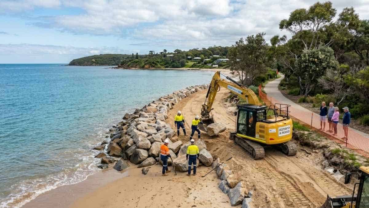
Australia continues to develop its role as an innovative region for sustainable coastal tourism by focusing on environmental renewal and the management of visitors in Oceania. In terms of erosion reduction at Windang, New South Wales and improved turtle conservation programs around Bundaberg in Queensland, the goal is to preserve these sensitive environments and contribute to the local economy through tourism. This is also the case for other countries in Oceania, such as New Zealand, Fiji, Samoa and Vanuatu, where these coastal areas and marine life play an important role in the attraction of tourists.
The estuarine velocity domino effect: Lake Illawarra entrance dynamics
Coastal barrier systems and barrier estuaries across eastern Australia exist in a delicate hydrodynamic equilibrium governed by tidal exchange, fluvial discharge, and littoral sediment transport. The Lake Illawarra estuary, situated south of Wollongong in New South Wales, underwent a major morphological transformation when state authorities constructed twin training breakwaters at its ocean entrance in 2007. Prior to this engineering intervention, the inlet opened and closed dynamically in response to storm surges, flood events, and coastal shoaling cycles, naturally dissipating mechanical wave energy across extensive sandy shoals and shallow bars. Permanently stabilizing the inlet created an unbroken marine conduit between the lagoon and the Tasman Sea.
This permanent opening altered the estuarine tidal prism. As ocean tides propagated inland through the constrained entrance, the hydrodynamics of the channel shifted from a low-energy barrier lagoon to an accelerated, tidally dominated conveyance zone. Elevated hydraulic gradients increased peak flood and ebb tidal velocities, with current speeds along the northern channel margin exceeding 1.0 metre per second. These sustained velocities initiated severe bed shearing and scour along the adjacent shoreline.
The resulting geomorphic adjustments concentrated along the Windang Foreshore. Detailed hydrodynamic modeling and cross-sectional bathymetric profiles completed by the Water Research Laboratory (WRL) identified this reach as experiencing the fastest erosion rates in the entire entrance channel. Between 2008 and 2022, sediment loss peaked at 20 cubic metres per linear metre per year, producing a vertical bed lowering of approximately 5 metres—equivalent to an annual vertical degradation rate of 0.35 metres.
Advertisement
Advertisement
This continuous scouring destabilised the shoreline, washing away an estimated 10 metres of public foreshore reserve. Critical community assets, including public fishing jetties and a foreshore playground, were undermined and destroyed. Scour scarps advanced toward local utility corridors, council roadways, the access corridor to the Windang Surf Life Saving Club, and the mature stands of Norfolk Island Pines (Araucaria heterophylla) that stabilise the recreational reserve.
The crisis underscored the systemic consequences of altering coastal hydrodynamics: localized interventions within dynamic coastal zones can trigger secondary erosion processes that compromise public safety, municipal amenities, and civic infrastructure. The estuarine velocity domino effect illustrates why long-term hydrodynamic modeling must guide coastal modifications before hard structures alter natural tidal exchange.
Advertisement
Advertisement
| Hydrodynamic & Geomorphic Metric | Baseline (Pre-2007 Channel) | Observed Post-Training Status (2008–2026) | Projected 20-Year Horizon (No Intervention) |
| Entrance Tidal Connectivity | Intermittent / Dynamic Shoaling | Permanently Trained via Breakwaters | Permanently Open Marine Conduit |
| Channel Current Velocities | Attenuated (<0.4 m/s typical) | Peak Velocities Exceeding 1.0 m/s | Sustained High Velocities (>1.0 m/s) |
| Foreshore Scour Rate | Dynamic Equilibrium / Low | Up to 20 m³/m/year Volumetric Loss | Progressive Destabilisation to Bed Rock |
| Vertical Bed Degradation | Minor Seasonal Accretion/Loss | ~5.0 m Lowering (0.35 m/year avg) | Continued Downcutting Along Outer Bends |
| Public Reserve Depletion | Stable Historic Tree Line | 10 m Direct Terrestrial Loss | Loss of Primary Road & Lifesaving Access |
| Impacted Infrastructure | None | Public Jetties & Playgrounds Destroyed | Roadway, Water/Sewer Lines, Pine Canopy |
Statutory evaluation frameworks: Review of Environmental Factors protocols
Halting erosion along the 330-metre section of the Windang Foreshore required a structured planning framework balancing engineering stabilization with estuarine conservation. In New South Wales, public infrastructure works within sensitive marine and estuarine environments must complete a Review of Environmental Factors (REF) under Part 5 of the Environmental Planning and Assessment Act 1979. The REF evaluates construction methods to limit disturbance to marine biodiversity, estuarine water quality, and native flora.
Engineering designs for the Windang site replaced informal revetments with an engineered rock revetment seawall. Rather than erecting vertical concrete bulkheads—which reflect wave energy and accelerate seabed scour—civil engineers selected a sloped rock revetment. This design relies on graded primary armor stone, secondary underlayers, and permeable geotextile filter fabrics. The geotextile layer stabilizes sub-surface soils while allowing pore-water pressures to dissipate, preventing the hydraulic suction that undermines unreinforced sea defences.
The revetment structure consists of carefully engineered strata:
- A deep toe trench armoring keyed directly into the scoured channel bed below the expected design scour depth, providing physical anchoring against undercut failures.
- A base layer of non-woven geotextile filter membrane laid over the regraded sandy bank to prevent fine subsoil washout.
- A secondary underlayer of graded quarry spalls and bedding stone designed to cushion the filter membrane and distribute structural loads.
- An interlocking primary armor rock layer composed of dense, angular igneous stone sized to withstand channel velocities exceeding 1.0 metre per second and localized boat wash.
- A stabilized crest connecting with a restored public pedestrian path, graded to prevent stormwater overtopping from scouring the rear of the wall.
The REF established strict construction protocols to protect the mature Norfolk Island Pines flanking the reserve. Heavy machinery footprints, excavation boundaries, and rock placements were designed to avoid root compaction within critical root zones. Gabion baskets and dynamic sand nourishment were integrated to absorb localized energy along transitions between hard armoring and natural sandy margins. In-water works required silt curtains and sediment traps to prevent turbidity from drifting into downstream seagrass meadows (Zostera muelleri and Halophila ovalis), which serve as nurseries for commercial and recreational fisheries. The project demonstrates how modern coastal civil engineering integrates structural protection with ecological habitat preservation.
First Nations cultural heritage preservation and archaeological workflows
The shores of Lake Illawarra have been home to the Dharawal people for tens of thousands of years. The lake’s entrance provided resources including estuarine fish, crustaceans, molluscs, and native coastal plants. As tidal flows cut into the Windang Foreshore, rapid shoreline erosion uncovered previously buried shell middens, stone tool knapping floors, and ancestral hearth locations, exposing them to wave damage and illegal collection.
To protect these cultural resources, Wollongong City Council and NSW Crown Lands integrated cultural heritage assessments and mitigation plans into the engineering design. Under the National Parks and Wildlife Act 1974 (NSW), ground disturbance along the shoreline requires consultation with the Illawarra Local Aboriginal Land Council (LALC) and Registered Aboriginal Parties (RAPs).
Advertisement
Advertisement
Archaeological teams conducted ground-penetrating radar surveys and test excavations along the 330-metre revetment alignment to map subsurface cultural horizons before site preparation began. Ground-disturbance protocols require that qualified Aboriginal site officers oversee all mechanical excavation, clearing, and trenching. If cultural materials are identified, works halt within a defined exclusion buffer to allow for salvage, documentation, and repatriation according to traditional protocols. Rather than sealing these sites away permanently, the project incorporates interpretive educational elements developed with traditional custodians, linking engineering protection with First Nations cultural heritage preservation.
Ecotourism operations and carrying capacity architecture at Mon Repos
Ranger-led access control and seasonal carrying capacity quotas
Located near Bargara, 14 kilometres east of Bundaberg, the Mon Repos Conservation Park supports the largest concentration of nesting marine turtles on the eastern Australian mainland and functions as the primary South Pacific rookery for the endangered Loggerhead turtle (Caretta caretta). The conservation park also provides nesting habitat for vulnerable Green turtles (Chelonia mydas) and Flatback turtles (Natator depressus), with occasional nesting by endangered Leatherback turtles (Dermochelys coriacea). The nesting and hatching season runs for five months from November to late March.
Managing high visitor numbers without compromising reproductive success required Queensland Parks and Wildlife Service (QPWS) to move away from unmanaged public beach access. Unregulated visitation leads to dune trampling, artificial lighting disturbance, and nest compaction. In response, QPWS instituted the Mon Repos ecotourism model based on strict carrying capacity principles.
The seasonal operation is structured across two biological phases:
- Nesting phase (November to mid-January): Adult female marine turtles haul ashore during high tides at night to excavate egg chambers and lay clutches in the foredunes.
- Emergence phase (mid-January to late March): Incubation concludes, and hatchling clutches dig their way out of sand nests to make their seaward crawl under cover of darkness.
Public access to the nesting beach at night is restricted to ranger-led Turtle Encounter tours. Visitors gather at the Mon Repos Turtle Centre starting at 7:00 PM and are assigned to departures based on booking order. Wandering unaccompanied along the foreshore is prohibited. Nightly quotas are capped, maintaining total seasonal visitation within an ecological carrying threshold of approximately 30,000 guests.
Rangers and conservation volunteers patrol the foreshore to locate nesting turtles or emerging clutches before bringing visitor groups down to the water. Guests observe egg laying and hatchling emergence under the direct supervision of scientific staff.
Advertisement
Advertisement
This visitor management framework generates substantial economic activity, injecting approximately $13.6 million annually into the regional economy through lodging, dining, and transport in Bundaberg and Bargara. The Mon Repos model demonstrates how high conservation standards can support strong visitor economies without compromising species protection. This robust carrying capacity architecture ensures that tourism activities remain within ecologically sustainable boundaries.
Photic management and low-impact infrastructure design
Artificial light is a significant hazard for nesting marine turtles and emerging hatchlings. Adult females avoid brightly illuminated beaches, while hatchlings rely on light reflected off the ocean to find the water; artificial lighting inland can draw them away from the sea, leading to exhaustion, dehydration, and predation. Photic management was therefore central to the design of the $13.6 million Mon Repos Turtle Centre.
The facility is set back behind the coastal foredune, using the natural dune topography and littoral vine forest as a light shield. External fixtures and pathway illumination utilize long-wavelength, suppressed red-spectrum LEDs operating at wavelengths above 590 nanometers, a light range that does not disrupt sea turtle vision. Windows and viewing portals are shielded with tinted glazing and smart louvers to eliminate light spill toward the beach.
Marine turtles possess photic sensitivity curves heavily skewed toward blue and green spectral bands (400 to 520 nanometres), which they use for oceanic orientation and navigation. High-intensity broad-spectrum illumination disorients hatchlings, leading to deadly misorientation inland. By shifting site infrastructure lighting entirely into deep amber and red spectra (>590 nanometres), the facility minimizes photic interference with nesting females and emerging hatchlings.
To limit trampling on turtle nests, pedestrian circulation is confined to elevated timber and composite boardwalks. These structures sit above the primary dune vegetation, allowing sand to move naturally beneath them and enabling nesting turtles to navigate the beach without encountering barriers. During the day, the centre functions as an educational facility featuring interactive scientific exhibits, generating year-round revenue for QPWS conservation programs and reducing reliance on seasonal tours.
Integrating First Nations narratives and historical landscapes
Mon Repos holds cultural significance for several communities. First Nations peoples have lived along this coast for millennia, coexisting with the seasonal turtle migrations and managing marine resources sustainably. The interpretive displays at the Turtle Centre reflect this history, presenting Indigenous knowledge of marine life and ecosystems alongside contemporary ecological science.
Advertisement
Advertisement
The reserve also contains dry-stone rubble walls built by South Sea Islanders in the late nineteenth century. Thousands of Pacific Islanders, brought to Queensland under exploitative labor arrangements, cleared volcanic rocks by hand to cultivate sugarcane fields across the Woongarra scrub. These hand-stacked basalt structures remain on the site, preserved as registered heritage features that document the history of Pacific Island laborers in regional Queensland.
These layers of history continue through the colonial and industrial eras. The property takes its name from French sugarcane pioneer Augustus Barton, who named his 1884 summer estate “Mon Repos” (French for “My Rest”). In 1893, the beach served as the landing point for the first underwater telegraph cable connecting Australia to New Caledonia, linking the Australian continent directly to international communications networks. In 1912, aviation pioneer Bert Hinkler conducted his first successful glider flights across the Mon Repos dunes, later achieving the first solo flight from England to Australia in 1928.
By interpreting First Nations culture, South Sea Islander history, early industrial telecommunications, and aviation achievements within an active wildlife sanctuary, Mon Repos balances environmental conservation with cultural stewardship.
Fiscal co-funding frameworks and seasonal economic sequencing
Intergovernmental co-funding models and capital allocation
Delivering large-scale coastal infrastructure requires sustained cooperation between local and state governments. The $8 million Windang Foreshore restoration uses a 50/50 capital split: $4 million provided by the NSW Minns Labor Government through Crown Lands, and $4 million matched by Wollongong City Council.
This joint funding arrangement was finalized through coordination among state and municipal leaders, including NSW Minister for Planning and Public Spaces Paul Scully, NSW Minister for Lands and Property Steve Kamper, and Wollongong Lord Mayor Cr Tania Brown. Minister Scully affirmed that stabilizing the 330-metre reach will restore safe community access, while Cr Tania Brown highlighted that matching state funding allows the council to deliver essential coastal defenses that protect public safety and foreshore open space. Joint financing allows municipal councils to fund major civil engineering projects that would otherwise exceed local ratepayer resources, while ensuring state-administered public lands remain protected and accessible.
In Queensland, the $13.6 million upgrade of the Mon Repos Turtle Centre was funded through the state government’s Protected Area Strategy and the Destination 2045 20-year tourism roadmap. Destination 2045 is backed by a $1 billion investment program from the Queensland Government, including $446 million in capital allocations, aimed at growing the state’s visitor economy to $84 billion annually by 2045. By funding conservation facilities through tourism infrastructure programs, the initiative links visitor spending directly to the long-term protection of natural assets.
Advertisement
Advertisement
| Infrastructure & Ecotourism Initiative | Total Capital Investment | Funding Partners & Allocation | Primary Strategic Objectives | Targeted Return & Economic Outcome |
| Windang Foreshore Restoration (NSW) | $8.0 Million | • $4.0M NSW Crown Lands • $4.0M Wollongong City Council | • Repair/construct 330 m rock revetments • Protect road, utilities, and pines • Preserve Aboriginal heritage sites | • Safeguard community access • Protect SLSC and reserve assets • Prevent further loss of foreshore |
| Mon Repos Turtle Centre (QLD) | $13.6 Million | • Queensland State Government • Third-Party Partner Funds • QPWS Capital Works | • Build low-light, low-impact facilities • Support loggerhead turtle conservation • Deliver year-round educational exhibits | • $13.6M annual regional injection • 30,000+ controlled seasonal visitors • Advance Destination 2045 targets |
Seasonal construction sequencing to shield small-business trade
Large civil engineering projects along coastal foreshores face significant operational challenges from tourism seasonality. The Windang Foreshore reserve, situated beside popular caravan parks and holiday accommodations, experiences high visitor volumes during the Southern Hemisphere summer, which peaks from December through late January. Starting construction during this holiday window would close public beaches, disrupt local trade, and harm small businesses that depend on summer tourism revenue.
To protect the local visitor economy, Wollongong City Council and NSW Crown Lands scheduled the start of civil works for early 2027, immediately after the peak summer trading period. The nine-month construction schedule will run through autumn, winter, and early spring, with completion targeted before the following summer holiday season begins.
The phased operational deployment follows an organized sequence:
- January to February 2027: Peak summer trading concludes, holiday crowds disperse, and municipal contractors mobilize site offices, boundary fencing, and plant machinery.
- February to April 2027: Marine contractors deploy heavy floating silt booms in the channel, clear unstable debris along the 330-metre reach, and excavate the basal toe trench under the guidance of First Nations monitors.
- May to August 2027: Heavy earthmoving equipment regrades the bank slope, lays down the geotextile filter fabric, and places primary armor stone and secondary underlayers along the intertidal zone.
- September to October 2027: Contractors complete the revetment crest, install root protection systems for the Norfolk Island Pines, construct the elevated shared pathway, and complete riparian planting.
- November 2027: The restored foreshore reserve, beach access points, and recreational amenities reopen to the public ahead of the peak summer holiday season.
This sequencing balances the logistics of coastal engineering—such as rock delivery, excavation, and revetment placement—with the economic needs of local business communities.
Regional visitor dispersal and domestic drive corridors
Coastal management projects support broader domestic tourism strategies across eastern Australia. Data from Tourism Research Australia’s (TRA) National Visitor Survey (NVS) highlights the growing value of domestic drive markets originating in capital cities such as Sydney, Brisbane, and Melbourne. Following changes in domestic travel habits, regional road trips have become an important source of economic activity for regional New South Wales and coastal Queensland.
TRA visitor accounts record a 38% year-on-year increase in New South Wales residents traveling along regional Queensland corridors, with many heading to destinations such as the Sunshine Coast, Hervey Bay, and Bundaberg. Drive-market itineraries are supported by accessible, well-managed natural and coastal attractions. Investments in foreshore amenities, such as the restoration at Windang and the facilities at Mon Repos, provide reliable regional anchors that encourage travelers to disperse beyond metropolitan centres, spreading economic benefits into regional towns and supporting long-term economic resilience.
Advertisement
Advertisement
Strategic adaptation matrix: Oceanian coastal protection and ecotourism
Coastal hazards such as sea-level rise, king tides, storm surge, and coastal erosion affect communities and tourist destinations throughout Oceania. Governments and local authorities across Australia, New Zealand, Fiji, Samoa, and Vanuatu are adopting adaptation strategies that balance hard engineering defenses, nature-based stabilization, and community ecotourism.
The matrix below outlines how these five Oceanian jurisdictions address environmental hazards through coastal engineering and destination management policies.
| Country / Territory | Key Gateway Cities | Regional Coastal & Ecotourism Hubs | Primary Environmental Hazard | Strategic Mitigation & Ecotourism Blueprint |
| Australia (NSW) | Sydney, Newcastle | Wollongong, Windang, Shellharbour, Kiama | Tidal scouring, estuarine erosion & public asset loss | $8M joint state-council rock revetment & heritage protection. |
| Australia (QLD) | Brisbane, Gold Coast | Bundaberg, Bargara, Hervey Bay, Cairns | Cyclonic storm surge & beach erosion | $13.6M ranger-guided ecotourism model under Destination 2045. |
| New Zealand | Auckland, Christchurch | Kaikōura, Rotorua, Tauranga, Napier | Post-seismic coastal slumping & coastal erosion | Managed retreat frameworks, bio-engineered seawalls & marine reserves. |
| Fiji | Nadi, Suva | Sigatoka (Coral Coast), Savusavu, Taveuni | High-tide inundation & coral barrier decay | Hybrid rock armoring paired with community mangrove restoration. |
| Samoa & Vanuatu | Apia, Port Vila | Espiritu Santo, Tanna, Salelologa | Coastal inundation & tropical cyclone damage | First Nations seawall engineering & eco-lodge retreat zoning. |
In New Zealand, the Department of Conservation and the Ministry for the Environment implement coastal hazard policies governed by the New Zealand Coastal Policy Statement (NZCPS). Following severe seismic events along the Kaikōura coast and ongoing coastal erosion in Tauranga and Hawke’s Bay, New Zealand planning authorities have moved toward managed retreat policies. These frameworks avoid ongoing investments in hard sea defenses where coastlines are retreating naturally, prioritizing bio-engineered revetments, dynamic gravel berms, and marine reserves that allow coastlines to adjust naturally.
Fiji’s coastal strategy along the Coral Coast and Sigatoka balances infrastructure protection with ecosystem restoration. Resorts and traditional village councils partner with the national government on hybrid seawall projects that combine sloped basalt armoring with intertidal mangrove nurseries (Rhizophora mangle). The engineered rock seawall breaks incoming wave energy, while mangrove roots stabilize sediments, capture organic carbon, and provide nursery habitats for reef species, sustaining local artisanal fisheries and reef tourism.
In Samoa and Vanuatu, local village authorities manage coastal protection using customary tenure systems and indigenous engineering. Communities on Savai’i (Samoa) and Tanna Island (Vanuatu) use volcanic boulders to construct sloped barriers, backed by native foreshore tree planting—including Calophyllum inophyllum and Barringtonia asiatica—to prevent shoreline retreat.
Zoning guidelines require that community-run eco-lodges are built landward of projected inundation zones, ensuring these tourism facilities remain intact through tropical cyclones and high-tide flooding. These regional approaches share common goals with the Australian projects: protecting local assets, maintaining ecological systems, and supporting sustainable regional economies. Together, they represent an integrated framework for Oceanian coastal protection across high-exposure island and continental environments.
Advertisement
Advertisement
Strategic policy implications and future roadmap for destination management
Multi-agency governance and cross-jurisdictional collaboration
The Windang Foreshore restoration illustrates the importance of intergovernmental coordination in addressing coastal hazards. Estuarine channels and coastal margins sit across overlapping jurisdictions, involving local municipal governments, state land authorities, fisheries agencies, and environmental regulators. Unclear management responsibilities can delay urgent stabilization works, allowing erosion to cause irreversible damage to shorelines.
Structuring projects with 50/50 capital co-funding agreements and clear statutory mandates under Reviews of Environmental Factors enables state and municipal bodies to share technical resources, pool funding, and implement long-term coastal management strategies.
This governance model is relevant across Pacific island territories, where national environment ministries must collaborate closely with provincial bodies, traditional landholding trusts, and commercial tourism operators to plan infrastructure works effectively.
Hybrid coastal defense architectures: Engineering with nature
The case studies at Windang and Mon Repos show that coastal management requires a combination of structural engineering and nature-based solutions. While hard engineering such as rock revetments is necessary to protect critical roads and public facilities from high-velocity tidal scour, hard armoring alone can create downstream scour problems if built without environmental safeguards.
At Windang, the sloped rock revetment design integrates geotextile filter fabrics, dynamic nourishment, and tree root protection to maintain foreshore stability without producing reflective wave turbulence.
At Mon Repos, natural foredune systems and coastal vine forests serve as physical barriers against coastal storms and screen artificial lighting from the beach, while elevated timber boardwalks allow public access without disturbing dune structures or turtle nesting sites. Combining engineered revetments with natural coastal buffers offers an effective, durable model for shoreline resilience.
Advertisement
Advertisement
Long-term climate adaptation and economic sustainability
As climate pressures intensify across the Pacific, coastal tourism will depend on the physical and ecological resilience of shorelines. Destinations that experience continued coastal erosion, asset loss, and biodiversity decline face declining visitor interest and rising recovery costs.
By contrast, jurisdictions that invest in durable coastal engineering, respect cultural heritage sites, and implement managed visitor access demonstrate that environmental conservation can support long-term economic growth.
The projects delivered at Windang and Mon Repos provide practical models for this balanced approach. By coupling civil engineering works with sustainable visitor management and dedicated funding mechanisms, municipal planners and conservation agencies can maintain accessible, safe, and ecologically intact coastlines for the future.
Sustaining dynamic shorelines while fostering visitor economies requires coordinated public leadership and informed ecological engineering. As demonstrated across eastern Australia, integrating durable revetment armoring with controlled carrying capacity protects both public safety and threatened marine wildlife. The successful implementations at Lake Illawarra and Mon Repos prove that proactive planning safeguards First Nations heritage, mitigates climate hazards, and stabilizes local commerce. For developing destinations throughout New Zealand, Fiji, Samoa, and Vanuatu, these initiatives establish that environmental resilience and tourism growth are inherently interconnected. Advancing coastal stewardship provides an enduring foundation for Pacific communities to protect fragile shores, honour ancestral living cultures.
Conclusion
Australia’s efforts in coastal restoration and ecotourism mark a larger shift taking place in the Oceania region where conservation and tourism are increasingly related. With New Zealand, Fiji, Samoa, and Vanuatu adopting sustainable practices, collaboration within the region and responsible management of visitors will be vital for the continued success of the tourism industry.
Advertisement
